The City of Puerto Princesa in Palawan, Philippines. Is located 306 nautical miles southwest of Manila, 205 nautical miles from Panay and about 250 nautical miles from Zamboanga. It is bounded on the North by the Municipality of San Vicente. And Roxas and on the the South by the Municipality of Aborlan. Its western side faces the South China Sea while in its eastern coast lays the Sulu Sea
Puerto Princesa City has a total land area of 253,982 hectares making it the largest City in the country.
The City is comprised of 35 urban barangays and 31 rural barangays. The total area of the urban barangays is 14,716 hectares or only 5.7941% of the total land area of the City. The largest land area of the City is comprised of the rural barangays with a total land area 239,266 hectares or 94.2059% of the total land area of the City.
Puerto Princesa City, a tropical paradise with a bustling urban center perfect for business with leisure trips. Lush rainforests and white sand beaches are simply hours away from the city proper, where a banking and commercial boom has made life easier for workaholics who can never run away from the office.
Puerto Princesa City is a relatively young settlement. It was established as a city only in 1970. The first settlers arrived here almost a century earlier though, on March 4, 1872, celebrated every year hence as the foundation day of Puerto Princesa.
Its narrowest breath is in Bahile, where only 8.5 kilometers of land separate the east and the west coast.
More info
Majority of which are rural settlements scattered in underdeveloped land. Inhabitants number about 150,000, most of them engaged in agriculture and fishing. A third of the population resides in the city proper, an urbanized settlement on the shores of Puerto Princesa Bay. With its huge trees and fresh air, the city has managed to retain its frontier ambiance despite the onset of modern trends and structures.
Puerto Princesa Philippines climate consists of pronounced wet and dry seasons equally divided throughout the year. The wettest month is September while the driest month is February. From October to April, the northeast monsoon whips up waves on the coast facing the South China Sea. The southwest monsoon blows from April to August.
The best time to visit Puerto Princesa would be the summer months from April to June, when seas are usually calm. Humidity is high but annual average temperatures are comfortable at 27 degrees celsius. Nights may be chilly during rainy days, especially in forested areas, so it is advisable for visitors to bring warm clothing at all times.
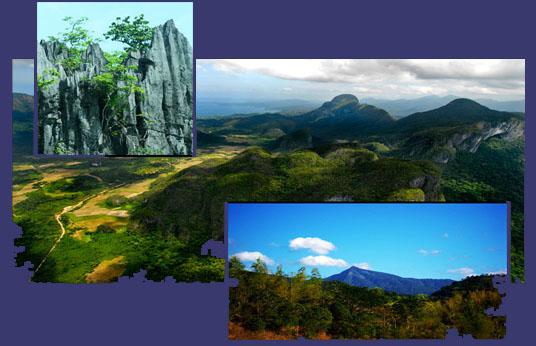
Geology
In the southern portion particularly in the Irawan area, metamorphic rocks of the Inagawan Formation can be found. The area is also partly composed of sedimentary Iwahig Formation, alluvium of unconsolidated gravel, sand, pebbles and silt. Some ultramafic rocks of the Palawan Ophiolite Complex also characterize the area.
The northern part of the City is comprised of ultramafic rocks. In particular, the Langogan area is characterized by metamorphic rocks consisting of quartz-feldspathic and mica schists, phyllites, slate and quartzites. The ultramafic rocks consist of unaltered sepertenized pridotite, dunite and pyrexomite.
Babuyan area is made up of Irahuan Metavolcanics which resemble the quartz-hematite schist in appearance and are also friable and weather into dark reddish gray platy fragments which are usually scattered near outcrops of river beds. St. Paul limestone outcrops as small patches are found in the south and midwestern part of the catchment. It is comprised of a very thick, massive, marbleized limestone with very well developed karst.
More about its geology
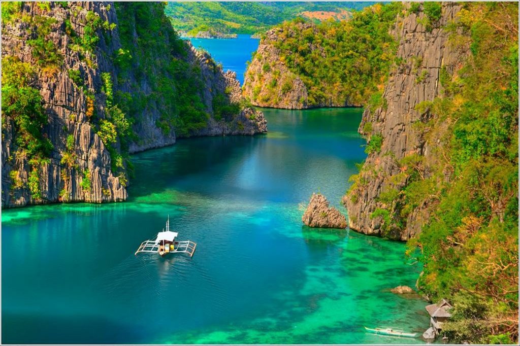
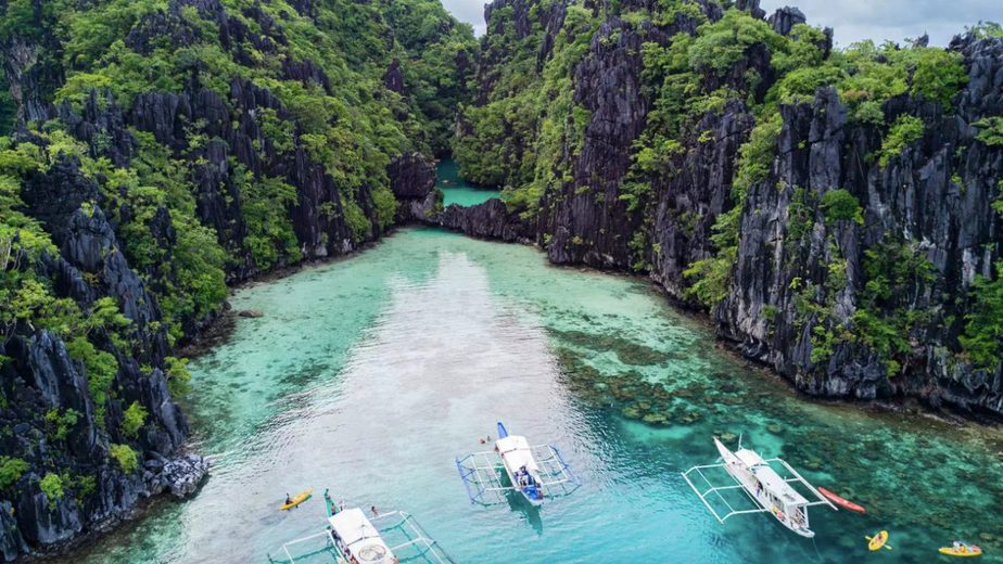
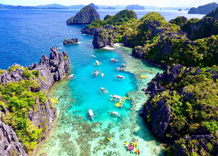
The Puerto Princesa Subterranean River National Park has karsts limestone formation and is popular tourist destination among local and international tourists. The underground river is about 8.2 kilometers in length and has been proclaimed under Proclamation No. 212 as a National Park. The park covers a protected area of 22,202 hectares. It is also included in the list of World Heritage Sites by UNESCO because of its diverse ecosystem and the presence of rare flora and fauna. The site, which is located in Sabang, barangay Cabayugan has also fine white beaches.

The underground caves stretch for more than 24km and they contain the last 9km of the Cabayugan River before it spills out into the Philippine Sea. The caves are a breathtaking combination of stalactites, stalagmites, caverns, waterfalls, domes and rivers.
Puerto Princesa Underground River is one of the longest underground rivers in the world. Board a boat at the mouth of the cave at Sabang Wharf, and stop at the Buenavista viewpoint for views of Ulugan Bay.
History of Puerto Princesa
Legend attributes the name “Puerto Princesa” to a princess-like maiden who in the early days is said to have roamed around the place on certain nights of the year. On the other hand, practical people attribute the name to the geographical advantages of the place as a seaport – naturally protected the whole year round and endowed with a depth that can accommodate any size of shipping – a royal heaven for vessels or a virtual princess of ports as thus indicated by Spanish Colonizers on the country’s map.
Historically, the place was named after Princess Asunción, born in 1864 to Queen Isabella II and her consort, Francisco de Cádiz. When the princess suffered an untimely death, the Queen changed the name to Puerto de la Princesa. Eventually, the name was reduced to Puerto Princesa as it is known today.
Spanish Colonizers founded the settlement on 4 March 1872 in the course of their exploration of the province. As they scanned the Palawan shoreline for a capital site, they came upon a hill with steep declivity. Rowing to shore, they surveyed the hill and discovered an extensive plateau which they decided as ideal for settlement.
In continuation
In May 1872, the Port of Puerto Princesa became the center of Spanish Naval Operations in the area. Because the Bay met all the Navy’s requirements. Royal Decrees later provided incentives to settlers, and by 1883 the settlement had flourished into a town of twelve roads, a hospital and well-built port.
Puerto Princesa was recognized in 1894 by government authorities as one of the most beautiful towns in the country. And by virtue of the orderly distribution of streets, buildings and houses as well as the cleanliness of the community.
And in 1911, the New American Administration made Puerto Princesa the seat of the Palawan Provincial Government with Major John Brown as Lieutenant Governor.
In 1956, the sitios of Calagbenguen, Tarabanan, Bendoyan, Talabigan, Tagbuan, and Langogan were constituted into the barrio of Concepcion.
The town was converted into a city on 1 January 1970 under R.A. 5906 as amended by P.D. 437, through the effort of then Congressman Ramon V. Mitra, Jr. Feliberto R. Oliveros, Jr. became the first City Mayor.
Since its foundation, Puerto Princesa has been the nerve center of activities in Palawan. Aside from being the seat of public administration, it is the heart of trade, commerce, service, and industry in the province.
Today, the City has gained the distinction of being a model city – in cleanliness, environmental protection and conservation, and local governance in general.
And so, with a responsive leadership and an inspired citizenry. The tradition of Puerto Princesa being a beautiful and clean city lives on.